
 Viết ít nhất 150 từ trong khoảng 20 phút.
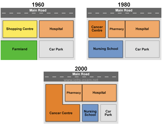
The maps show the changes at Queen Mary Hospital and the area around it in 1960, 1980 and 2000.
Overall, the hospital site became more developed over time, with more medical facilities. The shopping centre and the farmland disappeared, and the car park became smaller.
In 1960, the hospital was in the north-east of the site, next to the main road. There was a shopping centre on the west of the hospital, farmland in the south-west, and a car park in the south-east.
By 1980, the shopping centre had been replaced by a cancer centre and a pharmacy. The pharmacy was next to the hospital. The farmland had been removed and a nursing school was built there. The car park was still the same.
In 2000, the cancer centre became much bigger, and it covered most of the west side of the site, including part of the area of the nursing school. The nursing school was moved and became smaller, and the car park was also reduced in size. The hospital and the pharmacy did not change.