IELTS Writing Task 1 · Map

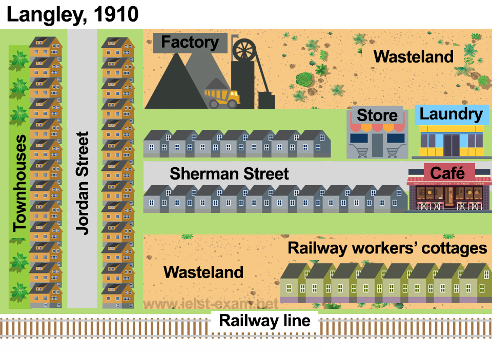
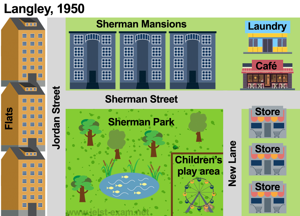
Bài mẫu IELTS Writing Task 1: The maps below show the town of Langley in 1910 and 1950.

Bản đồ 20 phút · tối thiểu 150 từ Bài mẫu 6.0 Bài mẫu 7.0 Bài mẫu 9.0 trong app

Đề bài

The maps below show the town of Langley in 1910 and 1950.

Summarise the information by selecting and reporting the main features, and make comparisons where relevant.

IELTS Writing Task 1 Map: The maps below show the town of Langley in 1910 and 1950. IELTS Writing Task 1 Map: The maps below show the town of Langley in 1910 and 1950. Viết ít nhất 150 từ trong khoảng 20 phút.

Dàn ý gợi ý cho dạng Map

Xem tất cả đề dạng Map →

So sánh một khu vực ở hai thời điểm (hoặc hiện tại và quy hoạch). Cần mô tả những gì thay đổi, những gì giữ nguyên, kèm vị trí.

  1. Mở bàiParaphrase đề: khu vực nào, những năm nào.
  2. OverviewThay đổi tổng thể: đô thị hoá, thêm tiện ích, mất không gian xanh…
  3. Thân bài 1Thay đổi ở một khu vực (ví dụ phía bắc).
  4. Thân bài 2Thay đổi ở khu vực còn lại + những gì giữ nguyên.
  • Từ chỉ vị trí: to the north of, adjacent to, opposite.
  • Động từ thay đổi: was demolished, was replaced by, was converted into, was extended.
  • Dùng quá khứ/hiện tại hoàn thành phù hợp với các mốc thời gian.

Bài mẫu band 6.0

203 từ. Bài đủ ý, bố cục rõ, từ vựng và ngữ pháp ở mức an toàn: đây là mức nhiều bạn cần để đạt mục tiêu 6.0.

The maps show the town of Langley in 1910 and in 1950.

Overall, Langley changed a lot over the 40 years. The town became more residential with new flats and a big park, while the factory, the wasteland and the railway line disappeared.

In 1910, there were townhouses on both sides of Jordan Street in the west of the town. In the north, there was a factory next to some wasteland. Along Sherman Street, there were two rows of houses, and at the east end there was a store, a laundry and a café. In the south, there was another area of wasteland, some railway workers' cottages and a railway line.

By 1950, the townhouses had been replaced by blocks of flats on the west side of Jordan Street. The factory and the wasteland in the north were removed and Sherman Mansions was built there. The laundry and the café was still in the same place. The houses on the south side of Sherman Street, the cottages and the railway line were replaced by Sherman Park, which has a lake and a children's play area. Also, a new road called New Lane was built in the east, with three stores next to it.

Bài mẫu band 7.0

223 từ. So với bài 6.0: lập luận sâu hơn, từ vựng chính xác và đa dạng hơn, câu phức dùng tự nhiên hơn.

The maps illustrate the changes that took place in the town of Langley between 1910 and 1950.

Overall, Langley was transformed from an industrial town into a more pleasant residential area. Industrial features such as the factory and the railway line disappeared, while new housing, a park and additional shops were developed.

Còn 2 đoạn của bài 7.0 và bài mẫu band 9.0

Đăng nhập miễn phí để đọc trọn bài, so sánh 3 mức band và viết thử ngay trên đề này.

Đọc tiếp trong app