
 Viết ít nhất 150 từ trong khoảng 20 phút.
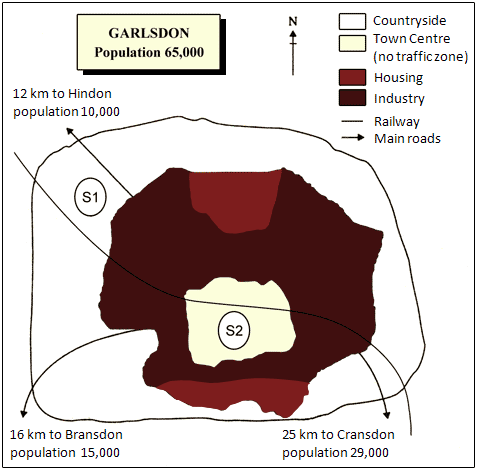
The map shows the town of Garlsdon, which has a population of 65,000, and two possible sites, S1 and S2, for a new development.
Overall, S1 is outside the town in the countryside, while S2 is in the town centre. Both sites are near the railway, but they have different advantages.
Garlsdon has a town centre in the middle, which is a no traffic zone. Around the town centre, there are housing and industrial areas, and the countryside is around the whole town. A railway goes through the town from the north-west to the south-east. There are also main roads to three other towns. Hindon is 12 km to the north-west and has 10,000 people. Bransdon is 16 km to the south-west with 15,000 people, and Cransdon is 25 km to the south-east with 29,000 people.
S1 is in the countryside in the north-west of the town. It is next to the railway and the main road to Hindon, so it is easy for people from Hindon to go there by car. S2 is in the town centre, and the railway also goes near it. It is close to the people who live in Garlsdon, but cars cannot drive there because it is a no traffic zone.