
 Viết ít nhất 150 từ trong khoảng 20 phút.
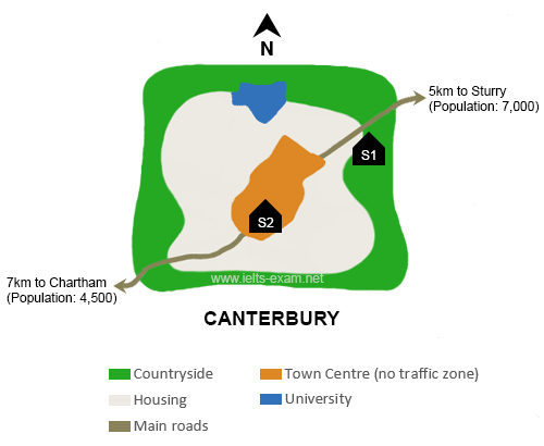
The map shows the town of Canterbury and two possible sites for a new school, S1 and S2.
Overall, the two sites are in different areas of the town. S1 is outside the town centre near the countryside, while S2 is in the town centre. Both sites are close to a main road.
Canterbury has a town centre in the middle, which is a no traffic zone. Around the town centre there is a large housing area, and the university is in the north of the town. The countryside is all around the town. There is a main road which goes through the town from the south-west to the north-east. In the north-east, the road goes to Sturry, which is 5km away and has a population of 7,000. In the south-west, it goes to Chartham, which is 7km away and has 4,500 people.
The first site, S1, is in the north-east of the town, between the housing area and the countryside, and it is next to the road to Sturry. The second site, S2, is in the south-west part of the town centre, near the road to Chartham. However, because it is in a no traffic zone, it may be difficult for cars to get there.