
 Viết ít nhất 150 từ trong khoảng 20 phút.
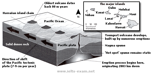
The diagram shows how the Hawaiian island chain was formed by volcanoes in the Pacific Ocean. The small map shows the location of the major Hawaiian islands.
Overall, the islands were created by a hot spot under the Pacific plate. As the plate moves slowly, new volcanoes are formed, so the islands become older from one end of the chain to the other.
The process starts very deep under the ground, about 2,883 km down. Here, there is a hot spot, and magma rises up from it in a spume. This hot spot does not move. The magma goes up through the Pacific plate, which is made of solid dense rock, and it erupts. After many eruptions, a new volcano is built up, and it becomes an island.
The Pacific plate moves about 7 to 9 cm every year. Because of this, the volcano moves away from the hot spot, and a new volcano starts to form above the hot spot. This happens again and again, so a chain of islands is made. The oldest volcano is about 80 million years old. The map shows that the main islands include Niihau, Kauai, Oahu, Molokai, Lanai, Maui, Kahoolawe and Hawaii.